
At R2V Digitization, we go beyond basic GIS services — we transform traditional geospatial information into intelligent, actionable digital formats. Specializing in Raster to Vector (R2V) conversion, we ensure that your analog maps and records are brought to life with accuracy, clarity, and precision.
With years of expertise in GIS and map digitization, our team delivers high-quality vector outputs tailored for scientific research, urban planning, infrastructure design, and utility management.
Our Expertise in Geospatial Digitization
We specialize in the digital conversion of a wide variety of legacy map formats and paper-based geospatial data, including but not limited to:
- Telecommunication Networks
- Sewerage and Drainage Systems
- Gas and Water Supply Lines
- Hot Water and Plumbing Networks
- Electrical Networks (Low & High Voltage)
- Digital Cadastral Plans and Property Maps
Our GIS digitization services cater to private enterprises, government bodies, and urban development agencies that require clean, editable, and georeferenced digital data.
Our Digitization Services Include:
- Paper Map Digitization – Convert old paper maps into high-quality digital formats for archival and analysis.
- Parcel/Tax Map Digitization – Accurate parcel boundary conversion for land records, tax departments, and cadastral systems.
- Onscreen Digitization – Vectorization of raster maps using advanced GIS tools for editable outputs.
- CAD Digitization – Seamless conversion from physical blueprints or scans to CAD-compatible vector data.
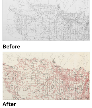
- Topographic and Utility Mapping – End-to-end digitization of terrain features and urban utility networks.
Why Choose R2V Digitization?
- High Accuracy Outputs – Every digitized feature is validated to ensure spatial integrity.
- Experienced Team – We bring in-depth knowledge of GIS, remote sensing, and cartography.
- Custom Solutions – From urban planning to utility design, we tailor our digitization to your project goals.